
Recognition Tab
In this tab, users can select a set of algorithms to be used for raster image vectorization.
To vectorize raster images of different type, various sets of geometric entities need to be used. For example, to vectorize maps or schemes the use of polylines would be suitable, approximating raster curves of arbitrary form; to vectorize engineering drawings algorithms that create lines, circles, arcs should be used – in this case a vector figure obtained will correspond exactly to the original drawing.
To make recognition of different image structures more versatile, WiseImage supports a set of vectorization algorithms that recognize raster analogues of vector entities and generate approximate vector objects of the corresponding types. One or more algorithms can be used in one operation.
 On the right side of the Recognition tab there is the Entities tree. On the first level there are recognition algorithms. To turn on the necessary algorithm, on a checkmark near its name. On the second level of the tree there are additional functions and parameters of corresponding algorithms. Algorithms that have such extra parameters of recognition are marked with
  symbols: if the second level is hidden
  , otherwise
  .
.
To get access to the hidden additional parameters of the algorithm, click on the “+” to the left of its name.
The vectorization process is directly influenced by setting of the geometrical parameters of recognition, which are located in the Options tab of this dialog box.
Points
This tool is intended for recognizing elevations marks on geodesic plans and similar images.
WiseImage will recognize a raster point with a size not less than 2×2 pixels (objects smaller than this are considered as speckle and ignored), and which maximum vertical and horizontal extents are not greater than Max Width value.
A point-object can be only recognized in automatic mode.
Do not switch this mode on when recognizing images of poor quality or images containing many speckles, since speckles can be recognized as points.
Lines
Turns on the tool for line recognition, the result is that line entities are created.
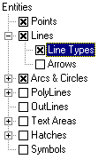
 The figure shows vectorization results when only the Lines tool is on. The original raster fragment is shown on the left; the figure on the right represents the vectorization results when objects width display option is off.

There are the following additional parameters:
| Arrows | If this option is on, then WiseImage searches for raster analogues of dimension lines (lines with one or two arrows at the end points) and, if the arrows are found, then WiseImage stores them as Start or End Marker property of the line. |
| Line Types | If this option is on, then WiseImage recognizes dashed and dash-dotted straight lines, creating vector lines with the corresponding line type. |
This tool is influenced by the following options of the Options tab:
It recognizes raster objects with a length greater than the value of the Min length parameter and with a width less than the value of the Max width parameter.
The Max break parameter sets the maximum length of ignored raster line breaks.
The Approximation parameter sets the accuracy of raster lines approximated by vector objects. If the raster quality is bad, then reduce the parameter value so that the tool can recognize raster objects with significant distortions of form.
If the Orthogonalization option is on, then recognized segments are aligned both parallel with and perpendicular to the direction specified in the Base angle field. The segments with small angles of deviation from appropriate directions are aligned. The accepted value of deviations, at which the orthogonalization is performed, is determined by the Approximating parameter. The closer this parameter is to the Low value, the larger the deviation can be.
Arcs and Circles
Sets the tool for raster circles and arcs recognition.
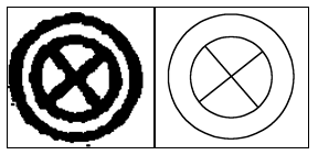 The figure shows the results of vectorization with the help of Lines and Arcs and Circles. The original raster fragment is shown on the left; the figure on the right represents vectorization results when object width display is off.
There are the following additional parameters:
| Arrows | If this option is on, then WiseImage Pro searches for raster analogues of dimension arcs (arcs with one or two arrows at endpoints) and, if the arrows are found, creates arc with arrows. |
| Line Types | If this option is on, then WiseImage Pro recognizes dashed and dash-dotted lines, creating vector objects with the corresponding line type. |
This tool is influenced by the following options of the Options tab:
It recognizes raster circles and arcs with lengths greater than the value of the Min length parameter and with widths less than the value of the Max width parameter.
The Max break parameter sets the maximum length of ignored raster segment breaks.
The Approximation parameter sets the accuracy of raster segments approximated by vector objects. If the raster quality is poor, then reduce the parameter value so that the tool can recognize raster objects with significant distortions of form.
Polylines
This tool approximates central lines of raster objects by polylines. The tool creates polylines consisting of linear segments only. This can be used individually (or with the tool Outlines) for vectorization of maps and other images consisting of arbitrary lines (curves drawn by hand).
There are the following additional parameters:
| Line Types | If this option is on, then WiseImage Pro recognizes dashed and dash-dotted lines, creating polylines with corresponding line types. |
| Create vertices on intersections | If this option is on, then the tool creates vertices on polylines intersections. |
This tool is influenced by the following options of the Options tab:
Max length defines the maximum length of a recognized segment that will be added to the polyline. The longer segments are not added to the polyline. This allows users, for example, to trace on maps curved isolines that are crossed by coordinate lines; the tool automatically stops on the intersection of traced isolines with the long straight line of grid.
The tool approximates raster lines with a width less than the value of the Max width parameter.
The Max break parameter sets the maximum length of ignored raster segments breaks.
The Approximation parameter sets the accuracy of approximating raster segments by vector polyline.
Outlines
This tool is used to approximate outlines of flooded areas by polylines. It creates closed polylines, approximating boundaries of raster objects. The boundary polylines consist only of straight segments.
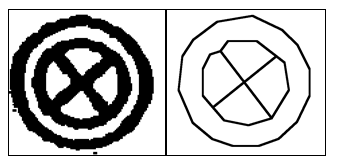
 The figure shows the results of vectorization with the Outlines tool only. The original raster fragment is on the left; the right figure illustrates vectorization result.
This tool is influenced by the following options of the Options tab:
The tool approximates raster lines with a width greater than the value of the Min width parameter. To obtain outlines of all raster objects, set the Max Width parameter to 0.
The Approximation parameter sets the accuracy of raster segments approximated by vector outlines.
Hatches
Set the tool for hatch recognition. WiseImage Pro recognizes simple raster hatches and creates blocks, consisting of lines. A simple raster hatch is a set of parallel raster lines. The Hatches tool searches for hatches only if the Lines tool is on.
The additional parameters are accepted angles of raster lines forming raster hatches.
Text Areas
Set the tool for text recognition. WiseImage Pro distinguishes areas on the image with raster texts and applies to the retrieved texts the operation set as the additional tool parameter.
Setting up of raster texts search options and the OCR module is made in the Texts tab of the same dialog box, the setting up procedure is described further in this chapter.
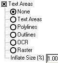 None – do not produce raster text vectorization. Areas, containing found raster texts are ignored.
Text Areas – creates rectangles bounding raster texts. These areas are not vectorized. Vector texts can be entered manually with the help of the review and correction procedure of recognized texts described below in this chapter.
Polylines – approximates central lines of the raster texts with polylines.
Outlines – approximates boundaries of the raster texts by polylines.
OCR – recognizes raster texts and creates text objects.
Raster – find raster texts and creates raster image with this text.
Inflate Size (%) – increases the found text area size in percent relative to the original.
The tool uses the values of the Height Table list of the Options tab as maximum height of uppercase raster text characters. See more information on this and other parameters that influence text recognition on Texts Tab.
Symbols
Set the tool for raster symbol recognition with specified samples. The tool only works if the tool Lines and Arcs and Circles are on. Setting up of the tool operation is made in the Symbols tab of the same dialog box as described on page 198.
Post your comment on this topic.