
Automatic Raster to Contours conversion
Performs a Raster to Contours conversion by polylines which duplicates selected closed areas on the image. At the same time, if an area has a mutual border (example shown below), every area (parcel) of polylines will have its own segment.
Setting up the Raster to Contours parameters can be performed in R2V Conversion Options.
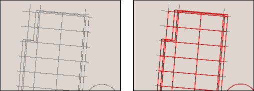
Increasing the Radius parameter causes more places to be treated as area borders
To start this command; choose Raster to Contours from the Convert menu or click the
 button on the Raster to Vector toolbar.
To perform conversion to contours do following:
1. Open the monochrome raster image.
2. Run this command.
3. If the Raster to Contours conversion is not suitable, then try changing the parameters in Conversion Options and re-running the command.
Post your comment on this topic.